Boston Snow Record Could Be Set This Week
BOSTON (CBS) - I am going to refrain from using the classic, go-to line when referring to an early March storm. You know, the whole "In like a lion…"
I feel like we are way past catch phrases this winter, we are better than that here in Boston.
Snowmaggedon, Snow Blitz, 6 more weeks of winter. Please, we are skipping the cutesy stuff and aiming higher, much higher. We are shooting for records. Not just run-of-the-mill, daily records either. We are going for the big ones.
We have challenged just about every winter milestone in the books this year and now our eyes are set on the big prize.
The holy grail of New England winter records. The equivalent of Joe Dimaggio's 56-game hitting streak, Ted Williams .406 batting average or Barry Bonds 762 home runs (except our winter isn't on steroids, at least not that we know of yet).
Of course, I am speaking of the greatest season snow total in Boston's recorded history, 107.6 inches in 1995-1996. This has stood in the number one spot without any real challengers, besting the former number two season (1993-94) by nearly a foot.
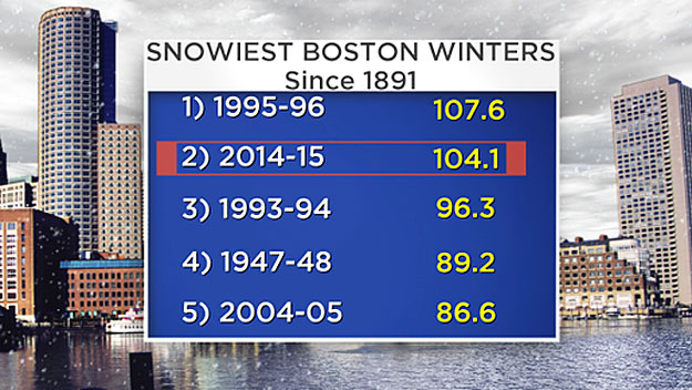
I say "former number two" because the winter of 2014-2015 now sits as the new number two, with 104.1 inches after Sunday night's 2.1 inches.
Just 3.5 inches from the number one slot, with the winter we have had, and it only being March 2, is there any doubt we won't break the record?
I would say it is a severe long shot. If I were a betting man, I would lay the odds of NOT setting a new record around 100-to-1, perhaps even higher. In fact, as it looks now, there is a better than 50-50 chance of breaking it this week!
A complex, spring-like winter storm is on the way, set to arrive Tuesday night. There will be snow, ice, rain and then perhaps more snow, literally a "kitchen sink" type storm. Let get into the details.
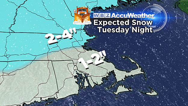
Tuesday Night:
The storm arrives after 7 p.m., starting as snow for all of southern New England. A heavy and wet 2-to-3 inches will accumulate in the first several hours, with perhaps some isolated 4 or 5 inch amounts well north and west of Boston.
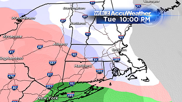
Around 10 p.m., warmer air will begin to stream in at upper levels of the atmosphere, changing the snow to an icy mix along the South Coast, Cape and Islands.
There will be no stopping the warmth from overtaking this storm. It will continue to flood in, first well above the surface, changing snow to sleet and freezing rain, and eventually at ground level, making a change to plain rain.
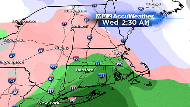
The tricky part of this forecast will be timing out that transition at the very bottom layer of the atmosphere (where we live). The deep snowpack will keep the ground refrigerated for quite some time. The cold air will be stubborn to dislodge, leading to some ice accretion, up to .1 of an inch on many surfaces late Tuesday night.
Wednesday Morning-Afternoon:
By dawn Wednesday nearly all the coldest air (below 32 degress) will have been scoured out leaving just plain old rain falling from the sky.
Even though surface temperatures will be above freezing, there could still be some icy areas given how cold and frozen much of our landscape is.
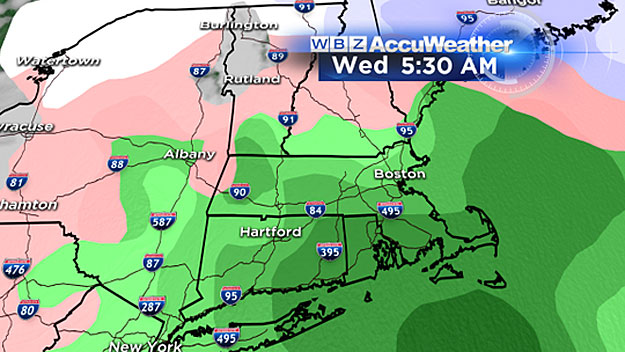
There won't be a whole lot of precipitation left on Wednesday, perhaps an additional quarter-to-half inch of rain during the early morning. Temperatures will rise well into the 30's in southern New England during the afternoon, perhaps as high as 40 in Boston.
Wednesday Night-Thursday:
The storm exits the region and cooler air drains back in. Temperatures will dip back below freezing. While the storm will be long gone, a stalled out frontal boundary will remain nearly stationary to our south. Additional waves of moisture will ride along this boundary, bringing snow back into southern New England.
This is a tricky forecast and a rather unusual setup with more precipitation arriving post-frontal, in the colder air. From 7 p.m. Wednesday through the day on Thursday, all of southern New England will be at risk for several additional inches of snow.
The highest risk of more plowable snowfall will be south of the Massachusetts Turnpike. This could be the final push needed to put us over the edge and into unchartered territory for seasonal snowfall in Boston. Any additional snowfall would likely taper off later on Thursday afternoon and evening.
In a nutshell, expect a very wet, sloppy couple of days ahead.
Additional strain will be put on roofs from the coming snow-ice-rain-snow sandwich. The days of "February fluff" are over. The storms keep coming, but now with more of a spring-like flavor.
After the snow exits Thursday we should stay dry through the weekend.
The next shot at additional storminess looks to be around next Monday.
At least this time it will come during Daylight Saving Time.
The clocks go ahead an hour this weekend.
Small steps. Spring will come, baseball will be played, the grass is out there - somewhere.
Follow Terry on Twitter @TerryWBZ