Blizzard Of 2015 Forecast: What To Expect
BOSTON (CBS) - We are now in the belly of the beast. Storms like this one do not come very often (thank goodness).
What we are experiencing right now in southern New England, you may only see a handful of times in your lifetime. If Boston reaches the two-foot mark in snowfall total, this would go down as a once in 25-years event. It would rank up there with storms like the April Fool's Day storm of 1997 and the infamous Blizzard of '78.
Check: Weather Blog | Current Conditions | Share Photos
At the very least, this storm will almost certainly get a place in the top 10 in Boston's snowy history. So, remember this one, it just might be a story for the ages, one you will bring up to your kids or grandkids someday.
Enough of the nostalgia, let's get down to basics. Here is what we can expect over the next 24 hours or so.
MORNING
A raging blizzard. Snowfall rates will range from 2-to-4 inches per hour within some very heavy bands rotating east to west.
Sustained winds between 20-40 mph across all of eastern Massachusetts with gusts 40-to-60 mph. Right at the coastline and particularly over Cape Cod and the Islands, wind gusts will likely exceed 60 mph, reaching near hurricane force (74 mph). Whiteout conditions will make driving, walking or generally existing outdoors impossible.
Everyone in southern New England will wake up to a tremendous amount of snow. Six-to-12 inches north of the Massachusetts Turnpike and 12-to-18 inches south of the Pike.
Even though tides will not be astronomically high, the sheer force of the winds will pile up a lot of water along the coast. Astronomical high tide in Boston Tuesday morning is 10.5 feet. There could be a storm surge up to 3.5 feet, which would result in moderate coastal flooding with pockets of major flooding. Seas just offshore will build to between 20-to-25 feet!
MIDDAY-AFTERNOON
The blizzard conditions become more sporadic and scattered within heavy bands of snow.
Snowfall rates will vary with banding. In the heavy bands, up to 1-to-3 inches per hour is still possible.
By noon on Tuesday expect 12-to-18 inches on the ground north of the Pike and 16-20 inches south of the Pike.
Winds will continue to howl but start to veer to a more northerly direction. Gusts between 40-to-60 mph will still be common and up to 70 mph on Cape Cod.
During the afternoon, conditions will begin to slowly improve in some areas. There will be north-south orientated bands with blinding snow about 10-to-20 miles wide and on either side of these bands, conditions will be much more hospitable with just light to moderate snowfall.

EVENING
By 6 p.m. on Tuesday expect a widespread 14-to-24 inches of snow across the region. About 80-percent of the total snow accumulation will be done at this point. Winds will remain powerful but out of the north-northwest, mainly an offshore direction. Astronomical high tide in Boston Tuesday evening will occur at 5 p.m. and be at 9.5 feet, a foot lower than the AM high tide.
However, the waters will have continued to pile up along the coast throughout the day with 30 foot waves just offshore. I expect that the evening high tide will be just as destructive as the morning version, perhaps even a bit worse in some spots. Snowfall will become more showery with persistent heavy bands followed by significant lulls in the action.
OVERNIGHT - WEDNESDAY MORNING
The final bands of snow will rotate through, dropping our last several inches of snow.
The storm will begin to finally lift north and east, away from New England. Winds stay gusty but not as damaging.
High tide at 5:30 a.m. shouldn't be a major concern with winds now pushing offshore, just some pockets of flooding. The massive cleanup and dig out can begin in earnest.
FINAL SNOW TOTAL PROJECTIONS:
Cape Cod/Islands: Six-to-12 inches on the extreme outer Cape and Nantucket due to some mixing and low snow ratios. Snow totals increase dramatically traveling west down Route 6, up to near 2 feet at the Canal.
Southeastern Massachusetts including South Shore, South Coast, Norfolk, Plymouth and Bristol Counties: Right now this appears to be the "jackpot" area. Twenty-to-30 inches are easily within range here. Perhaps up to 3 feet of snow in spots.
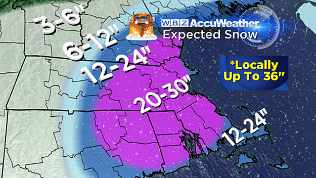
Boston area, nearby suburbs: Twenty to-30 inches, again, nearing a top 5 event all-time in Boston if we reach 2 feet.
North and west of Boston including 495 area from Lawrence to Marlboro and out to Worcester, most of Essex, Middlesex and Worcester Counties and southern New Hampshire: 18-to- 28 inches.
Farther north and west including western MA, southern VT and central New England: A bit farther away from the storm and the heavy banding, so slightly less snow totals: 12-to-18 inches.
Northern Ski Areas: Not the jackpot region but they will take it. Easily a foot of fluff up there perhaps up to 16 or 18 inches in spots.
Follow Terry on Twitter @TerryWBZ