Freezer Door Opens For Valentine's Day Weekend
Find Eric Fisher on Twitter and Facebook
I'd like the start this post with an inappropriate comment on Valentine's Day, cold weather, and your loved one...but the corporate overlords would likely frown upon such a thing. So I'll let your imagination do the work. You know what's coming by now - a frigid blast of air that we haven't had to deal with so far this winter. But how cold are we talking here? A 3 dog night, an extra log on the fire night, or a Netflix and abandon thoughts of leaving the house situation? Below are the details for the cold hearted.
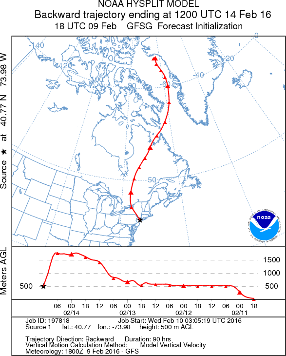
Where's this bouquet of cold air coming from? Mother Nature has decided to deliver it straight from the North Pole. Well, northwest Greenland to be exact. Most of this extremely cold polar air has remained bottled up to the north or across Asia this winter. Our air masses have been primarily Pacific origin, which is why this winter is running so far above average in terms of temperatures. But this weekend's air has been slowly steeped in the dark and frigid regions of the arctic. Ready to visit, thankfully for only a 3-4 day stay.
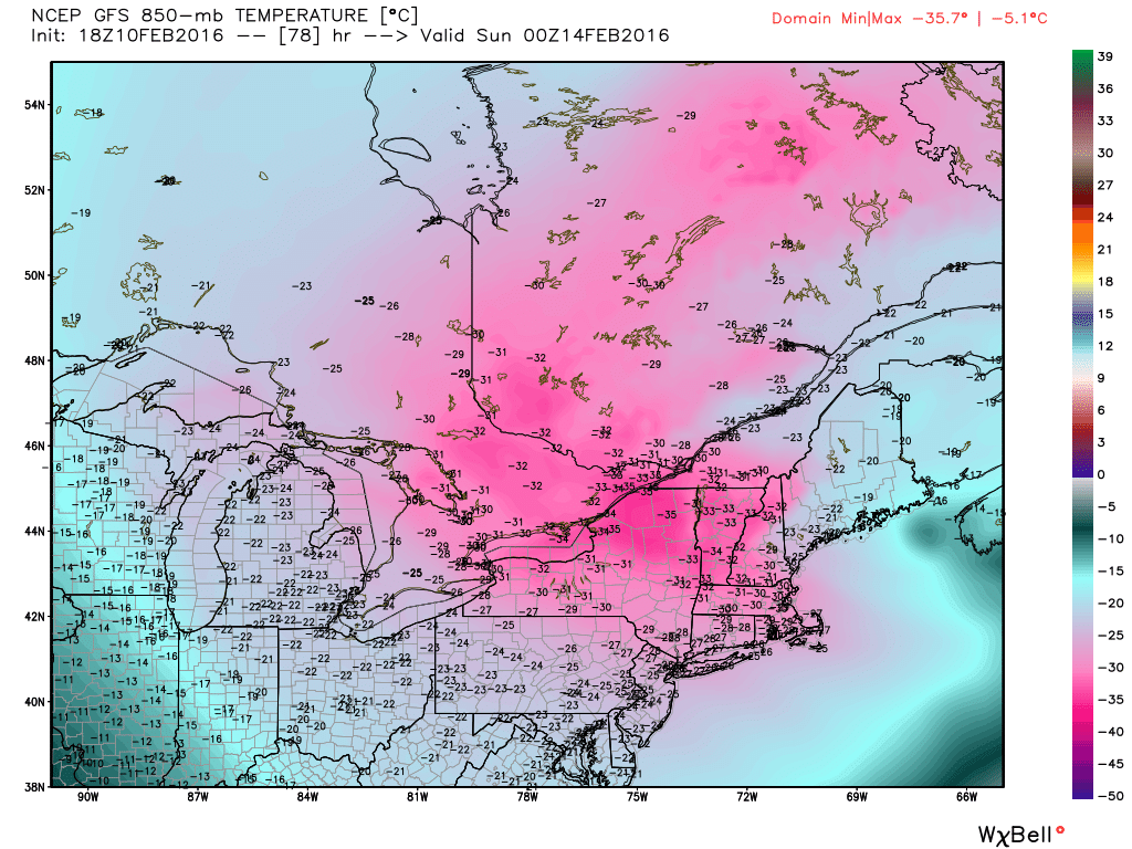
The real 'cream of the crop' cold in the world of Northeast winter weather is when you see -40C at 850mb. That's rare air, and we won't be too far off the mark on Saturday. Most of the Northeast will be engulfed in temps at 850mb ranging from -30C to -35C, which translates to many towns failing to get out of the single digits (and many northern New England areas not even reaching 0F). We have a small window to hit 15-20F on Saturday before plummeting back through the 10s and 0s during the afternoon and evening. And an air mass this cold has the potential to produce some well below zero numbers at night.
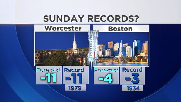
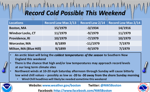
How low will it go? Record territory is certainly in play, and we don't set many of those anymore in Boston. In fact, even in last winter's brutal stretch from January through March, we didn't set a single daily record low. Sunday morning's current record is -3F, which was set on Milk Street before record keeping moved to Logan Airport in 1936. Worcester's record is -11F. It'll be close, but I'm sure you'll agree it's quite cold enough. If we get to that -4, it will be the coldest temperature in 12 years for the city of Boston.
Courtesy NWS Taunton
Interestingly enough, the coldest air last winter came on nearly the same exact same day. Valentine's Day seems to have a bit of a curse going...2 snowstorms the last 2 years, and the coldest weather of the winter on what will now be 2 consecutive years. This leads to many a restaurant owner cursing the local meteorologist, but don't blame the messenger! Blame Phil for getting false hopes up. In any case, I promise to go out with the wife on Sunday regardless to spend some hard earned coin. I'll be the one wearing a ski mask and a snuggie.
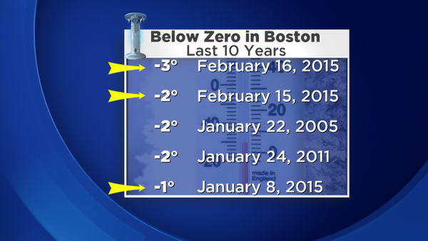
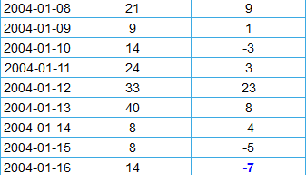
You can see from the graphic above that going subzero is a fairly rare occurrence in Boston. Only 5 times in the past 10 years, and only 9 times in the past 21 years. Most of those occasions have come in clumps during some serious cold air outbreaks. One of those was during last year's extreme winter, and the other recent chunk was back in 2004. That stretch was one of the worst in recent memory. Take a look at that run from the 8th of January through the 16th. For some contrast, we've only had 1 night reach the single digits all winter long so far in Boston! (There were 15 of them last winter)
The four nights below zero in a month ties the most on record (at Logan) with December 1942. And that -7F probably sticks out. That's the coldest temperature in the city in the past 59 years. Otherwise you have to go back to January 1957, when we dipped to -12F.
I think we're prime for a cold reading in Boston because our coldest overnight lows often come during strong cold air advection situations, where the frigid air is pouring into the region, versus a calm and clear night. The reason for that is due to the Urban Heat Island effect (UHI). Many areas outside of the city have their coldest nights when the air is calm and the sky is devoid of clouds. But in the city, heat tends to linger as buildings and human activity continue to radiate heat at night. Many times it can be 15F in Boston, but -10F in Norwood. A different kind of setup is needed to get us to the real cold stuff. This Sunday morning provides such a situation.
Monday morning will be the opposite - less wind. So the big league cold will be in the suburbs (well below zero) while Boston will probably barely get to 0F, if at all. And a note for photographers - conditions should be perfect for arctic sea smoke on any water bodies that are not frozen over on Monday morning! Should be a great opportunity at sunrise for an amazing winter shot.
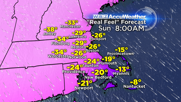
If it was just the cold this wouldn't be as big of a deal, but the wind will complicate matters on Saturday and Sunday. Frequent northwest gusts of 20-40mph will produce a biting and dangerous wind chill, the type you don't take too lightly. Expected wind chill values of -20 to -35F can lead to frostbite in 10-20 minutes on exposed skin. So if you're feeling adventurous and heading out, lots of layers are advised. Plus it's not a great idea to let the kids out, or pets for that matter. Very limited time outdoors is the way to go for this pair of days.
Okay so enough of the bad news...what comes after the cold? A break. After a very cold Monday morning we'll rebound into the 20s at least, which relatively speaking will feel much better. Then by Tuesday we'll be tracking the next storm moving toward us. Right now an inside track or one very close to the coast is looking likely, which would manage to get us at least into the 30s if not the 40s. And overall the pattern, while still active and chilly, does not look all that bad by February standards going forward. So once we pass this weekend, we can probably say that the coldest weather is behind us. Can't say the same for snowfall, but at least we probably won't need to talk about numbers like this until another winter comes knocking.