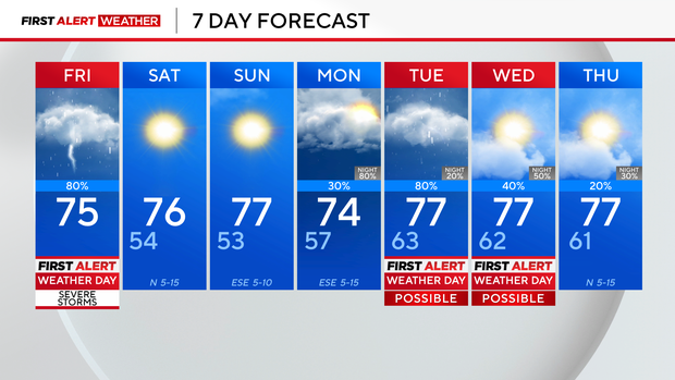
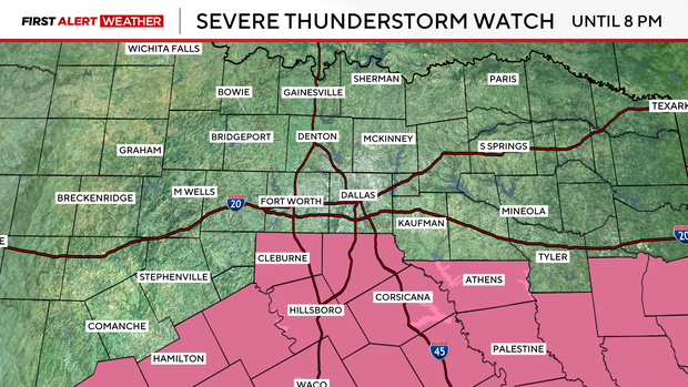
Severe thunderstorm watch for parts of North Texas as weekend begins

A severe thunderstorm watch is in effect for counties to the south of Dallas-Fort Worth until 8 p.m. Friday. This includes Johnson, Ellis, Hood and Navarro counties.
Friday afternoon, the atmosphere in North Texas destabilizes and upper-level lift increases during the heat of the day. Those ingredients all lead to an increase in storm coverage.
In the upper levels, there is an interesting pattern developing with an upper low over the Ohio Valley and one on the West Coast. This creates a ridge over the Plains to Southern Plains, which means nice and quiet weather for North Texas.

Early next week, storm coverage increases, especially Tuesday as there could be short-wave energy wrapping around the low-pressure system. Scattered strong to severe thunderstorms and locally heavy rainfall will be possible.
While rain chances persist into Wednesday, the atmosphere may be somewhat stabilized by earlier activity, reducing both storm coverage and severe potential.
By Thursday, the upper low shifts into the Southern and Central Plains, and another shortwave is expected to trigger storms late Thursday into Friday, once again posing a risk for severe weather and heavy rain. As the system drifts southeast into the lower Mississippi Valley by next weekend, lingering rain chances will be mainly confined to East Texas.