Tornado warnings in Philadelphia, New Jersey canceled as severe weather hits region

A tornado warning for Burlington County, New Jersey, was canceled on Tuesday night as severe weather continues to hit the Philadelphia region.
Earlier Tuesday, two separate tornado warnings were issued for Philadelphia and the surrounding suburbs, but they have since expired or been canceled.
The severe weather that rolled through the Philadelphia region caused power outages and even suspended services on SEPTA's West Trenton rail line because of a downed tree on the tracks.
The transit agency said services will remain suspended until Wednesday as emergency personnel work overnight to remove the tree and repair overhead wires.
Tuesday's weather forecast brought two distinct risks to the Philadelphia region. Our meteorologists issued a NEXT Weather Alert for excessive heat during the day and chances of storms at night – both of which our regions endured.
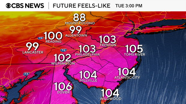
The morning started calmly but was incredibly humid, and heating throughout the day peaked with a high temperature of 94 degrees, which felt more like 101-104 by the mid-afternoon. This combination can put people at risk for heat-related illnesses.
The National Weather Service issued a severe thunderstorm watch that is in effect for several Pennsylvania and South Jersey counties and all of Delaware until 9 p.m.
A flash flood warning is in effect for Burlington, Camden, Bucks, Montgomery and Philadelphia counties until 10 p.m. It's also in effect for New Castle, Gloucester, Salem, Chester and Delaware counties until 9:45 p.m.
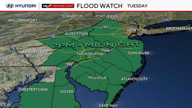
The region is under a slight risk for severe weather, or level 2 out of 5. The whole region is also under a flood watch, highlighting a possible impact of the storms.
The storms will begin to weaken through Tuesday night, but conditions will remain quite warm and muggy.
The remnants of Tropical Storm Chantal helped usher in the unsettled pattern that we will continue to see through the remainder of the week.
The chance for a few isolated afternoon showers and thunderstorms will return Wednesday afternoon, with even better rain chances through the second half of the week and into the weekend. In fact, this unsettled weather pattern will likely continue into at least the first part of next week.
Here's your 7-day forecast:
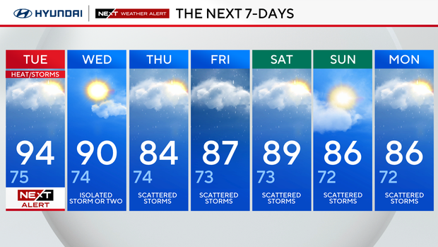
Tuesday: NEXT Weather for heat, storms. High 94, Low 75.
Wednesday: Isolated storm or two.. High 90, Low 74.
Thursday: Scattered storms. High 84, Low 74.
Friday: Scattered storms, High 87, Low 73.
Saturday: Scattered storms. High 89, Low 73.
Sunday: Scattered storms. High 86, Low 72.
Monday: Scattered storms. High 86, Low 72.