Northern California to see warm finish to week before cooler Mother's Day
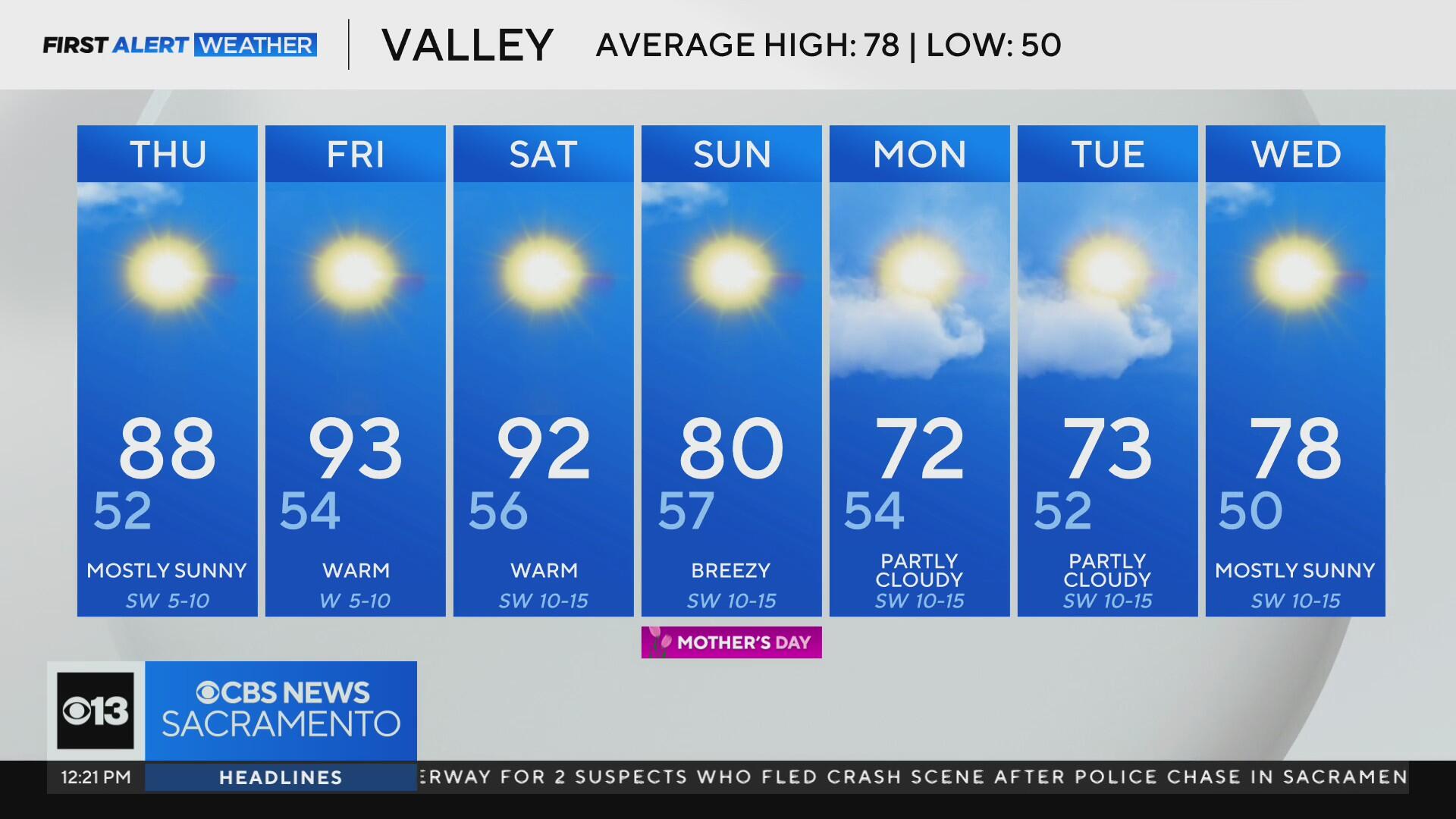
The ups and downs of spring continue this week in Northern California with above-average temperatures and a cooler finish to the weekend.
Wednesday brought a brief relief as our Delta Breeze helped to cool us down after a warm start to the week.
But this cool down will be short-lived as temperatures heat up Thursday through Saturday.
Delta Breeze returns
It was a refreshing start to Wednesday. Temperatures have been 8 to 16 degrees cooler than Tuesday's, with highs only reaching the upper 70s and low 80s.
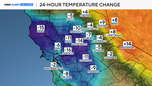
Since the weekend, valley highs have been in the upper 80s to low 90s. A warm start to the week with a strong north wind helped increase fire danger and dry out grasses.
This is the time of the year to be mindful of where you park and when you mow to not spark a fire.
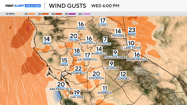
The Delta Breeze will linger through Wednesday evening before changing direction by Thursday. As breezes calm Wednesday night, valley temperatures dip to the low 50s.
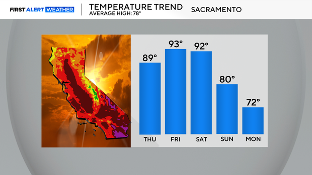
Warm finish to the week
Another warming trend begins as we finish the week. High pressure rebuilds over Northern California, helping temperatures return to the upper 80s, near 90 degrees on Thursday.
By Friday and Saturday, most of the Valley, Delta and lower foothills will be in the low 90s. For some, this will be the warmest temperatures we've seen so far this year.
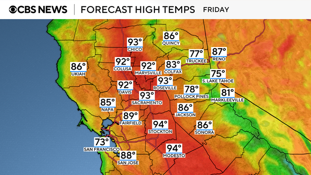
Places such as the Central Valley and California's high deserts could hit triple-digit highs to end the week. A little taste of summer in May.
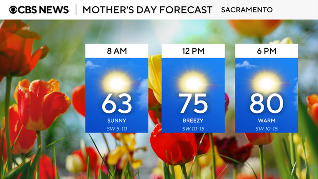
The unseasonably warm weather will stick around through Saturday, before the wind returns as we head into a breezy, cooler Mother's Day on Sunday.
A cool down by Mother's Day
By Sunday, the wind begins to increase as another storm system approaches Northern California.
The afternoon will be nice with plenty of sunshine and breezy winds. Temperatures across the valley will fall about 10 degrees compared to Saturday, with highs in the upper 70s to low 80s. Still a great day for any afternoon plans outdoors to celebrate with mom.
By Sunday evening, clouds begin to move in across the northern Sacramento Valley as our storm system moves in.
Looking ahead to next week, there is a chance for a few showers, mainly focused on areas north of I-80 and higher elevation spots.
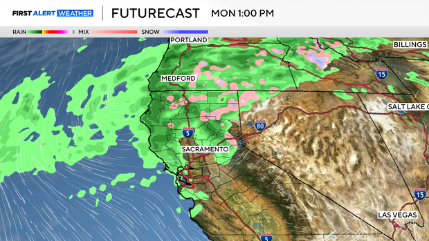
Sacramento could see a few light showers Monday evening into early Tuesday. Rain chances look very light for now, especially across the valley, with most receiving less than 0.10''.
Spots in the foothills and Sierra could get an extra 0.25-0.50'' of precipitation by Wednesday morning. Light snow is possible too along the Sierra peaks, especially for locations above 7,000 feet.
Water Safety
A reminder, as temperatures begin to heat up, now is still not the time to dive into our local waterways and lakes.
The water is still very cold, as most of it is snowmelt coming down from the Sierra.
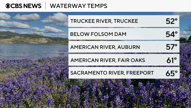
This week, most local waterways had a temperature of 50 to 60 degrees. In temperatures like these, cold water shock and hypothermia can become real dangers, even though the water may not seem dangerously cold at first.
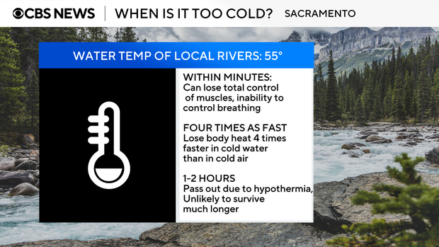
Make sure to always wear a life jacket when out on the water and have a plan in place in case you suddenly go in.
Stay with the CBS Sacramento First Alert Weather for any changes to the forecast heading into the summer months.